Japan faces an exceptional weather crisis this weekend as two distinct typhoon systems converge on the island nation, prompting the Japan Meteorological Agency to issue urgent landfall warnings on Friday. The dual threat from Typhoon Higos, advancing from the Pacific Ocean, and Typhoon Mekkhala, already bearing down on southwestern regions, has forced unprecedented evacuation measures across multiple prefectures and raised alarm about cascading natural disasters across the country.
Authorities have already begun mobilising populations in vulnerable areas. According to the Fire and Disaster Management Agency, more than 2 million residents spread across 13 prefectures in the Kinki and Kyushu regions received evacuation orders by Friday morning as rainfall accumulated to dangerous levels. The situation took on heightened urgency when Seika in Kyoto Prefecture, located in the Kinki region, triggered its maximum level 5 emergency safety alert after a major landslide struck the town during Friday morning, signalling the immediate peril residents face even before the main typhoon systems arrive.
The rainfall already unleashed across Japan's western and eastern territories demonstrates the ferocity of the approaching systems. Official measurements reveal the staggering accumulation of precipitation in recent days: Goto in Nagasaki Prefecture recorded 600 millimetres of rain between Tuesday and Friday morning alone, while Aso in Kumamoto Prefecture and Ureshino in Saga Prefecture each received more than 500 millimetres during the same period. These figures underscore how the weather systems have already begun affecting broad swathes of the country, with secondary effects now cascading through communities.
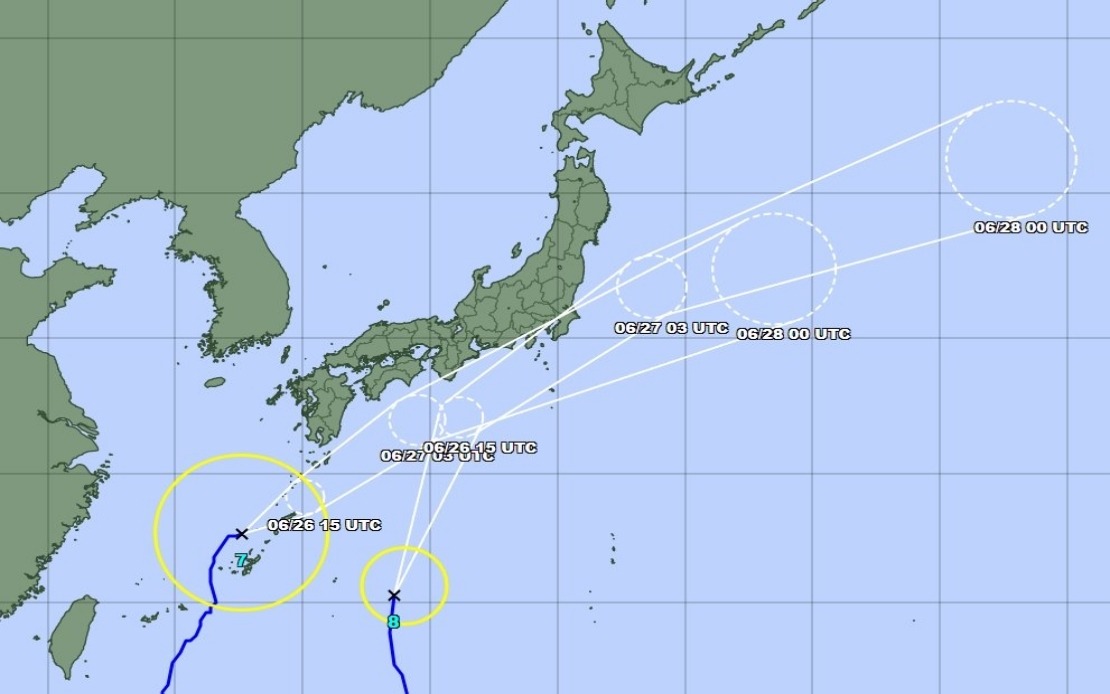
The meteorological agency's concern extends beyond the immediate impact zones to encompassing regions that will face danger as both typhoons move inland. Typhoon Mekkhala, detected moving northeast at 15 kilometres per hour off Kume Island in Okinawa Prefecture as of Friday morning, poses an immediate threat to Okinawa and islands throughout the region. Simultaneously, Typhoon Higos approaches from the Pacific, setting up a scenario where the Kanto region and surrounding areas will experience compounded rainfall from two independent but overlapping storm systems throughout Saturday.
Meteorological forecasters anticipate significant precipitation increases as these typhoons transit toward central and eastern Japan. The Tokai region faces projections of up to 300 millimetres of rainfall by noon on Saturday, while the Kanto-Koshin region is expected to receive up to 150 millimetres. Though these figures appear modest compared to the rainfall already recorded in southwestern areas, the additional moisture combines with ground already saturated from days of heavy rain, creating conditions where flooding and additional landslides become increasingly probable regardless of the absolute rainfall volumes.
The sequential movement of these weather systems through Japanese territory means that evacuation and response operations cannot simply conclude after one typhoon passes. As Higos moves northward along the country's southern coast, rainfall intensity will escalate across the Tokai and Kanto regions, continuing through Saturday as Mekkhala simultaneously approaches from the south and east. This overlapping trajectory creates a weather scenario where different prefectures face distinct but nearly simultaneous hazards, straining emergency response capabilities and requiring sustained vigilance across multiple regions.
The meteorological agency expects both typhoons to gradually weaken into extratropical cyclones once they interact with Japanese land masses and cooler waters, a process that typically diminishes wind speeds but does not necessarily reduce flooding risks. The transition from tropical to extratropical systems often shifts the danger profile from wind damage toward precipitation intensity and duration, potentially extending the crisis period beyond the initial landfall window. This distinction carries practical implications for emergency management, as teams must remain prepared for sustained effects rather than brief, intense impacts.
Regional variations in vulnerability add complexity to the crisis management effort. The Okinawa Prefecture faces immediate exposure to Mekkhala's core as the system moves northeast, while southwestern prefectures including Kagoshima, Nagasaki, Kumamoto, and Saga already contend with saturated ground and damaged infrastructure from five days of preceding rainfall. The Kanto region, encompassing Tokyo and surrounding prefectures, faces the convergence of both systems arriving nearly simultaneously on Saturday, creating a scenario where the country's most densely populated zone experiences compound hazards from dual weather sources.
For Southeast Asian observers, Japan's response to this meteorological emergency offers instructive lessons in preparedness and coordination. The rapid deployment of evacuation orders affecting millions of people, the issuance of maximum-level alerts, and the continuous updating of rainfall forecasts demonstrate institutional mechanisms that many developing nations aspire to but struggle to implement consistently. Yet even Japan's advanced warning systems and robust infrastructure face genuine challenges when multiple simultaneous disasters threaten different regions, raising questions about resilience limits in an era of increasingly volatile climate patterns.
The economic implications extend beyond the immediate emergency period. Disruptions to transportation networks, agricultural damages in rural prefectures already affected by extended rainfall, and potential industrial impacts from flooding in manufacturing-dependent regions like Tokai require days of recovery even after water recedes. Insurance claims, business interruption costs, and infrastructure repairs will accumulate across multiple prefectures, creating economic effects that ripple through supply chains serving regional and global markets.
Japan's experience with this dual typhoon threat reflects broader trends affecting East Asia's weather patterns. The region has witnessed increased frequency of near-simultaneous tropical cyclone systems in recent years, challenging historical assumptions about storm spacing and intensity distributions. Meteorological agencies throughout the Western Pacific region have progressively upgraded forecasting capabilities and warning systems, yet the convergence of multiple systems remains among the most difficult scenarios to communicate to public authorities and the general population, as competing hazards in different locations demand simultaneous resource allocation and attention.
The coming 48 hours will determine whether Japan's preparedness measures prove adequate to the challenge. Millions of evacuated residents await news of safety for their homes and communities, while emergency responders prepare for potential rescue operations and infrastructure damage assessments. The agency's continued warnings emphasize maintaining public alertness for secondary hazards including landslides and flooding that may persist well after either typhoon system weakens, reflecting the complex cascade of dangers that extreme weather systems trigger across vulnerable landscapes.