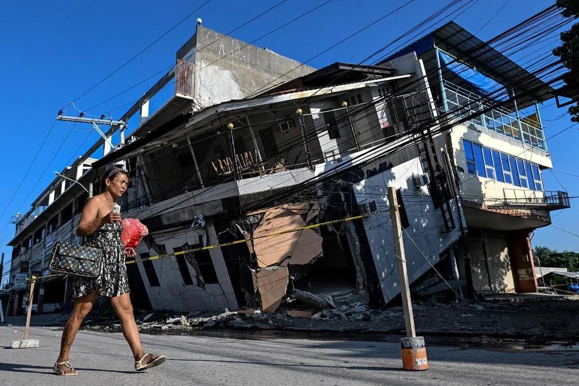
The June 8 earthquake that devastated Mindanao's southern coast did far more than topple buildings and claim at least 76 lives. The 7.8-magnitude quake, triggered by movement along the Cotabato Trench, fundamentally reshaped the landscape itself, lifting stretches of seafloor upward in a dramatic display of tectonic power that geologists call coastal uplift. For families who have fished these waters for generations, the transformation has turned a familiar environment into something unrecognisable, casting doubt on whether they will ever safely return home.
Arsenio Butil Jr, a fisherman and pastor in Sarangani province's Glan municipality, experienced the upheaval firsthand. As the ground shook beneath his feet, he watched the shoreline undergo a mesmerising and terrifying metamorphosis. The sea receded dramatically, then returned, then receded again—a cycle he witnessed perhaps three or four times as the tectonic forces beneath the earth's crust worked their way through the region. What struck him most was the scale of the change: fishing boats that had bobbed in shallow waters just days earlier now lay stranded on the wrong side of a jagged wall of exposed coral, dead and bleached, stretching for kilometres in both directions. The sensory experience of watching a landscape transform in real time left residents struggling to comprehend what they were seeing.
According to the Philippines' seismology centre, the Cotabato Trench—situated just 50 kilometres offshore—lifted the seabed by approximately two metres. This vertical displacement extended the shoreline by as much as 200 metres in some locations, permanently altering the geography of a zone stretching between two towns nearly 100 kilometres apart. Nane Danlag, a seismologist at the centre's General Santos City office, described the shift as permanent and part of a larger geological pattern. "What they see now is their new coastline," she told journalists, noting that such movements, while shocking to witness, represent natural tectonic processes that have been reshaping the region for thousands of years. Yet knowing the science behind such changes offers little comfort to those whose livelihoods and homes have been destroyed.
The Cotabato Trench itself remains a zone of intense geological activity. In January, the region experienced a seismic swarm of thousands of predominantly minor tremors, which a United Nations disaster risk reduction report released in mid-May suggested could presage a major earthquake. That prediction proved grimly accurate. Since the June 8 quake, more than 8,500 aftershocks have rattled the region, keeping residents in a state of heightened anxiety and preventing meaningful reconstruction efforts. Each tremor, no matter how small, reinforces the fear that another major quake could strike at any moment, potentially causing further devastation to already-damaged communities.
The displaced have not returned to rebuild. About 100 people—fishermen, their families, women and children—remain encamped on higher ground, unwilling to descend to their destroyed homes despite the passage of days. Datu Atom Malimpnig, a Maguindanaon chieftain representing the group, explained their reluctance in terms that reflect both fear and rational concern. The newly elevated coastline has created an unsettling new reality: if the seafloor can rise two metres, many reason, why couldn't the sea surge forward with equal or greater violence? The psychological impact of witnessing such a dramatic geological transformation has left them unconvinced that the danger has passed. Government aid workers continue to distribute rice porridge to the evacuees, a temporary measure that addresses hunger but not the deeper anxiety rooted in what they witnessed.
Beyond the human cost, the reshaping of the coastline threatens economic activities built around the region's marine environment. Isla Jardin del Mar, a resort that marketed white-sand beaches and tropical coastal experiences to tourists, now finds its primary asset rendered unusable. What was once an idyllic beachfront is now separated from deeper water by an extensive barrier of exposed, jagged coral. Resort staff member Edzel Baylon articulated the commercial catastrophe bluntly: the sea had become so shallow that swimming was no longer possible. For a destination dependent on the appeal of pristine waters and beach leisure, the geological transformation represents an existential threat to its business model. The tourism sector, already fragile across Southeast Asia, now faces yet another challenge in this vulnerable region.
The disaster exposes deeper vulnerabilities in Mindanao's preparedness and recovery capacity. Arsenio Butil Jr, reflecting on the immediate aftermath and ongoing dangers, highlighted the physical damage that makes reconstruction hazardous. Ground fissures, some extending for considerable distances, honeycomb the affected areas. These cracks are not merely cosmetic damage—they indicate structural instability that could collapse during aftershocks or future quakes of significant magnitude. Local residents, particularly those with memories of previous seismic events, understand intuitively that building on fractured earth requires either extensive engineering solutions or a willingness to accept elevated risk. For communities with limited resources, neither option is realistic in the short term.
The broader seismic context underscores why Mindanao remains particularly vulnerable to major earthquakes. The Cotabato Trench represents the meeting point of major tectonic plates, making the zone inherently unstable. The January swarm of thousands of tremors, while initially appearing ominous, was also expected by seismologists monitoring the region closely. Yet despite such warnings, early warning systems and evacuation protocols appear inadequate. The sudden coastal uplift, while scientifically explicable, caught residents and authorities largely unprepared for the scale of landscape transformation that would follow. The gap between scientific knowledge and practical preparedness remains a critical weakness in disaster management across the region.
For Malaysia and Southeast Asia more broadly, the Mindanao earthquake offers sobering lessons about seismic risk and coastal vulnerability. The region sits along the Pacific Ring of Fire, and while Malaysia experiences fewer major earthquakes than its neighbours, it is not immune to seismic events. Coastal uplift, tsunami generation, and submarine landslides triggered by earthquakes represent interconnected hazards that can cascade into regional disasters. The Philippine experience demonstrates that even when scientists understand the geological processes at work, translating that knowledge into effective protection and recovery remains a profound challenge. Communities dependent on marine resources and tourism must grapple with the possibility that their geography could change fundamentally within minutes, destroying decades of accumulated knowledge about local waters and coastlines.
As Arsenio Butil Jr and his community contemplate their uncertain future, they face questions without easy answers. Will the elevated shoreline stabilise, or will further tectonic activity continue to reshape the coastline? Can homes be safely rebuilt on fractured ground? Will the newly exposed coral ecosystem recover, or will it remain a barren monument to geological violence? These questions resonate beyond Mindanao, touching on fundamental issues of climate change, resource scarcity, and geological hazard management that affect all of Southeast Asia. The visible transformation of the landscape serves as a potent reminder that the earth beneath our feet is not static, and that the assumptions underpinning our communities—about where the shore lies, where it is safe to build, where we can fish and swim—can be undone in seconds.